My Genealogy Hound
Cook County, Illinois 1870 Map
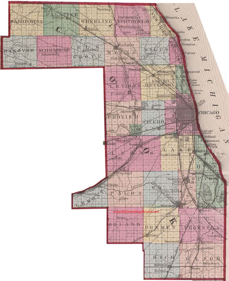
Locations shown include: Ainsworth, Austin, Belle Plain, Bloom, Blue Island, Bowmanville, Bremen, Brighton, Calvary, Canfield, Cazenova, Chicago, Cornell, Cottage Grove, Dalton, Deer Grove, Des Plaines, Dunton, East Northfield, Elk Grove, Englewood, Evanston, Glencoe, Glenwood, Grove, Harlem, Hawthorne, Holstein, Homewood, Hope Crossing, Irving Park, Jefferson, Kenwood, Lansing, Lemont, Leyden, Lincoln Park, Lyons, Lyonsville, Matteson, Morgan Park, Niles, North Evanston, Norwood, Oakland, Oak Park, Orland, Palatine, Palos, Park Ridge, Pine Grove, Proviso, Ravenswood, Rexford, Richton, Ringgold, Riverside, Rose Hill, Sag Bridge, Schaumberg, South Chicago, South Lynne, South Northfield, Schaumberg, Stratsburg, Summit, Thornton, Washington Heights Crossing, West Lyons, West Northfield, Wheeling, Wilmette, Willow Springs, Winnetka
The names shown in all caps are the names of the townships
This a portion of a map from Atlas of Illinois, by Warner & Beers, 1870
View additional Illinois Maps here: Illinois County Maps
County maps from other states can be viewed here: State County Maps
Additional Cook County resources: Cook County, Illinois History, Genealogy and Maps
Use the links at the top right of this page to search or browse thousands of family biographies.