My Genealogy Hound
Mitchell County, Kansas 1887 Map
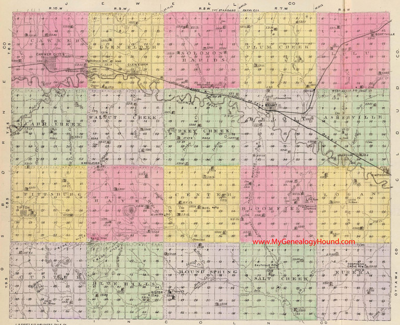
Locations shown include (click on any township name for an enlarged view):
Asherville Township: Asherville
Beloit Township: Beloit, Danville
Bloomfield Township: Walnut Grove
Blue Hills Township: Victor
Carr Creek Township
Cawker Township: Cawker City, Wauconda Springs
Center Township: Buel, Elmira
Custer Township
Eureka Township: Coursens Grove
Glen Elder Township: Concordia Station, Glen Elder
Hayes Township: Blue Hill
Logan Township: Simpson
Lulu Township: Scottville, West Asher
Pittsburg Township: Tipton
Plum Creek Township
Round Spring Township
Salt Creek Township: Saltville
Solomon Rapids Township: Solomon Rapids
Turkey Creek Township: Sol Rap Station (Solomon Rapids Station)
Walnut Creek Township: Excelcior (Excelsior)
The names shown in all caps are the names of the townships
This a map from Official State Atlas of Kansas, by L. H. Everts & Co., 1887
View additional Kansas Maps here: Kansas County Maps
County maps from other states can be viewed here: State County Maps
Use the links at the top right of this page to search or browse thousands of family biographies.